Vatersay
This is a walk of approximately 3 hours of easy to medium going with one short, fairly steep climb to Dun Vatersay. The walk begins at the small car park across the road
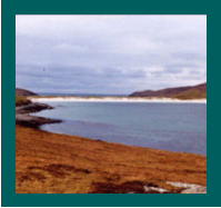
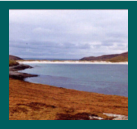
from the ‘Annie Jane' monument (situated overlooking Bagh Siar). It is a circular walk of about 4 miles, taking in Bagh Siar (West Bay), Bagh a Deas ( South Bay), Eorisdale
and Baigh Bhatarsaigh ( Vatersay Bay). There can be some boggy areas on route, so stout footwear should be worn.
The machair is entered by the gate across from the car park. This walk has stunning views, a number of archaeological sites and a chance of seeing a wide variety of birds,
but in the summer months is possibly more notable for the display of wild flowers than for any other feature.
Once on the machair a short walk brings you to the monument commemorating the emigrant ship ‘Annie Jane’ (from Liverpool, bound
for Canada), which was wrecked in 1853 at Bagh Siar with the loss of approximately 350 lives.
Leaving the monument and heading left along the beach takes you to the south end of Traigh Siar. Ahead and uphill is Dun Vatersay.
Marker posts are provided from here onwards. Before the last steep climb to the Dun, and to the left, the ground levels out. Here is the
site of a Bronze Age Kerbed Burial Cairn. It was excavated in the 1990’s by Sheffield University, and the remains of a cremated body were
found. A similar cairn about 200m to the south-west was also excavated, where some Bronze Age artefacts were unearthed.
On reaching the Dun (an Iron Age fort), you can appreciate the view and also the defensive position that it commanded. Unfortunately, it
has been almost totally robbed of stone (presumably for agricultural walling and housing). Heading downhill in a southerly direction,
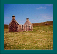
you pass behind what is left of Vatersay House. This was the house of the Tacksman (tenant farmer). It was built in the early 19th century,
when Gordon of Cluny owned Barra and Vatersay. In 1858, after Gordon's death, the estate passed to Lady Gordon Cathcart.
In 1909 Vatersay was compulsorily purchased and split into crofts by the Board of Agriculture. This took place in response to the demands of the group of crofters known as
’The Vatersay Raiders’, who had campaigned resolutely for land for themselves and their families.
Following the marker posts through a small valley, you pass the remains of what appears to be another
Bronze Age burial cairn.
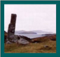
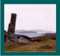
Slightly beyond this you should be able to see a standing stone. Whether it is a standing stone of great antiquity, to which a wall has been added, or a more modern gate-
post is open to question.
From the standing stone , there is a magnificent view of the islands to the south. The main islands are Pabbay, Mingulay and Berneray. Immediately to the left, across the
sound, is Sandray.
If you retrace your steps slightly, the trail heads in a south-easterly direction to Traigh Deas (South Beach). A number of birds can usually
be seen at the shore, including oyster- catchers, eider ducks and ringed plovers.
From the end of the beach, head uphill, following the marker posts. In the summer months this area is also covered in wild flowers. Blue
bells, clovers, orchids and ladies’ bedstraw are just a few to be seen. At the top of the hill you may find the largest display of gentians on
Vatersay, depending of course on the time of year.
Looking down to the south-west is the deserted village of Eorisdale. It was abandoned in the early 1970’s, when new housing became
available in Vatersay village. If you want to go down to Eorisdale, follow the marked trail along the left side of the valley and then head
straight down to the village, thus avoiding some very boggy ground.
Along the side of the valley are some old structures of indiscriminate date. The most interesting is a circular enclosure which probably served an agricultural purpose. A
similar enclosure is to be found at Ben Scurrival at the north end of Barra. Excavations there did not reveal a great deal as to its function.
Continuing along the trail, heading north towards Vatersay Bay (along the line of an old boundary wall) there are some structures thought to be Norse Boat Graves. These
are graves marked out with stones in the shape of a boat. There are similar structures elsewhere on the slopes around this area.
On the walk along the side of the bay, remember to look at the bay itself. Various birds can often be seen on the water, as well as gannets diving for fish. Also to be seen
occasionally are otters, seals and dolphins, and very rarely a basking shark. Near the beach, rectangular outlines are visible where buildings once stood, as well as the
remains of a pier. This is all that is left of a once thriving herring fishing industry. By the end of the 19th century, most of the trade had moved to Castlebay. Along the beach,
you have a pleasant stroll back to the car park. It should be noted that this is perhaps the safest beach on Barra and Vatersay for swimming.
Birds
Approximately 150 species of birds have been recorded on Barra, and a large number can be seen on Vatersay. Due to the varied terrain
on this walk, from machair land and sea shore to boggy ground, many types of birds can be seen. Among these are snipe, redshank ,
plovers, gannets, shags, eider ducks, ravens and buzzards.
Flora
Over 400 different species of plants have been recorded on Barra, and many can be seen on Vatersay.
Follow the crofting code.
Please ensure that dogs are kept on a leash at all times.
Park your car with consideration for others and do not block gates.
Fasten gates and use stiles provided to cross fences.
Leave no litter.
Try not to disturb breeding birds and animals.
Protect wildlife and plants.
Avoid damaging archaeological sites.
Permission to construct the heritage trails has come from the local crofters. Please remember that this ground is still used for crofting purposes.